FROM OUR CRASH COURSE
1. Which of the following is generally true ?
- The enclosed seas in lower latitudes record relatively higher temperatures than open seas.
- The enclosed seas in the high latitudes have lower temperature than the open sea .
- Only 1
- Only 2
- Both 1 and 2
- Neither 1 nor 2
FROM OUR TEST SERIES
2. Consider the following statements with reference to Joshimath:
- The town falls in high-risk seismic Zone-V
- It is traversed by running streams with a high gradient from Vishnuprayag
- Vishnuprayag is a confluence of the Dhauliganga and the Alaknanda rivers
Which of the above is/are correct?
- 1 and 2 only
- 2 and 3 only
- 1 and 3 only
- 1, 2 and 3
FROM OUR TEST SERIES
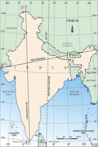
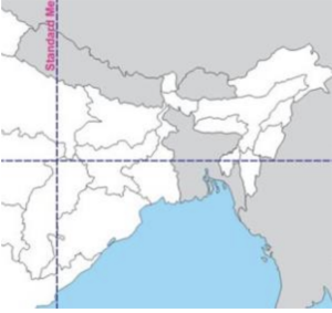
3. The Indian Standard Meridian does not pass through which of the following states?
- Uttar Pradesh
- Madhya Pradesh
- Rajasthan
- Chhattisgarh
4. What do you mean by the term “One Water Approach” ?
- To tap on one particular water source for all the households needs
- To form international standards based on which drinking water is to be provided to all
- Recognizing that all water has value, regardless of its source
- To have national strategy on water to reduce wastage and disputes on water sources
FROM OUR OFFLINE BATCH
5. Identify the sites associated with Uranium:
- Olympic Dam and the Ranger mine – Australia
- Athabasca Basin region – Canada.
- Chu-Sarysu basin – Kazakhstan
- 1 and 3 only
- 1 and 2 only
- 2 and 3 only
- 1, 2 and 3 only
Answers with Explanations
FROM OUR CRASH COURSE
1. Which of the following is generally true ?
- The enclosed seas in lower latitudes record relatively higher temperatures than open seas.
- The enclosed seas in the high latitudes have lower temperature than the open sea .
- Only 1
- Only 2
- Both 1 and 2
- Neither 1 nor 2
Answer: 3
Explanation
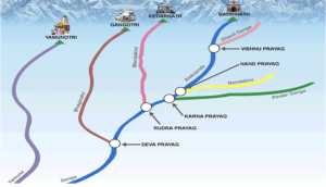
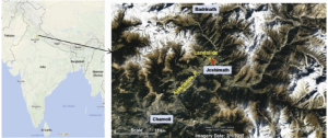
- The town (fall in high-risk seismic Zone-V) is traversed by running streams with a high gradient from Vishnuprayag, a confluence of the Dhauliganga and the Alaknanda rivers
FROM OUR TEST SERIES
2. Consider the following statements with reference to Joshimath:
- The town falls in high-risk seismic Zone-V
- It is traversed by running streams with a high gradient from Vishnuprayag
- Vishnuprayag is a confluence of the Dhauliganga and the Alaknanda rivers
Which of the above is/are correct?
- 1 and 2 only
- 2 and 3 only
- 1 and 3 only
- 1, 2 and 3
Answer: 4
Explanation
Joshimath Land Subsidence
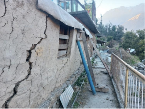
Joshimath Land Subsidence
- Geographical reasons – Ancient landslide site – • According to the 1976 Mishra Committee report, Joshimath is a deposit of sand and stone, it’s not the main rock.
- It lies on an ancient landslide.
- The report added that undercutting by river currents of Alaknanda and Dhauliganga are also playing their part in bringing landslides.
- These rivers washes away debris and thus, start cutting the edges of mountains and inhabitated area
Prone to Earthquakes –
- Joshimath falls under the highest seismic hazard Zone V as it experiences continuous seismogenic stresses.
- Joshimath almost sits on the Vaikrita Thurst (VT), a tectonic fault line. The town is also very close to main geological fault lines, Main Central Thrust (MCT), and Pandukeshwar Thrust (PT).
- Seismic energy generation due to microearthquakes may have weakened the strength of the rocks as Joshimath is located in the earthquake rupture zone of the 1999 Chamoli earthquake.
- Climatic factors such as excessive precipitation and flow of water from mountains into massive cracks and fractures in the sub-surface rocks lead to the widening of cracks and hastening the slip in rock material.
- The impact of extreme rainfall events is visible in latest satellite data, which shows that mountain streams have expanded their channels and changed course, thereby inducing more slope instability in an already fragile belt. Scattered rocks in the area are covered with old landslide debris comprising boulders, gneissic rocks, and loose soil, with a low bearing capacity.
- These gneissic rocks are highly weathered and have a low cohesive value with a tendency of high pore pressure when saturated with water, especially during monsoons.
- Improper water drainage – • Experts and USDMA pointed out reasons for increase in ground seepage of water from surface, a probable cause for subsidence. First, on-surface anthropogenic activities have blocked natural water drainage systems, forcing water to find new drainage routes.
- Second, Joshimath town does not have sewage and wastewater disposal system. The seepage reduces the shear strength of the overburden soil.
- Construction Activities – • Increased construction, hydroelectric projects, and the widening of the NH have made the slopes highly unstable in the last couple of decades. • Deforestation
FROM OUR TEST SERIES
3. The Indian Standard Meridian does not pass through which of the following states?
- Uttar Pradesh
- Madhya Pradesh
- Rajasthan
- Chhattisgarh
Answer: 3
Explanation
FROM OUR ONLINE BATCHES
Standard Meridian – States – Uttar Pradesh, Madhya Pradesh, Chhattisgarh, Odisha and Andhra Pradesh.
4. What do you mean by the term “One Water Approach” ?
- To tap on one particular water source for all the households needs
- To form international standards based on which drinking water is to be provided to all
- Recognizing that all water has value, regardless of its source
- To have national strategy on water to reduce wastage and disputes on water sources
Answer: 3
Explanation
- ‘One Water’ is the recognition that all water has value, regardless of its source. It includes managing that source in an integrated, inclusive and s
- Sustainable manner by including the community, business leaders, industries, farmers, conservationists, policymakers, academics and others for ecological and economic benefits.
FROM OUR OFFLINE BATCH
5. Identify the sites associated with Uranium :
- Olympic Dam and the Ranger mine – Australia
- Athabasca Basin region – Canada.
- Chu-Sarysu basin – Kazakhstan
- 1 and 3 only
- 1 and 2 only
- 2 and 3 only
- 1, 2 and 3 only
Answer: 4
Explanation
Distributiion of Uranium – World
- Largest viable deposits – Australia, Kazzakhstan and Canada
- Olympic Dam and the Ranger mine – Australia
- Athabasa Vasin Region – Canada
Chu-Sarysu Basin – Kazzakhstan
➡️ UPSC 2023 General Studies Course: https://sleepyclasses.com/general-studies-for-upsc/
➡️ Sociology Optional for UPSC: https://sleepyclasses.com/sociology-for-upsc/
➡️ Political Science and IR for UPSC: https://sleepyclasses.com/psir-for-upsc/
➡️ Signup here – https://sleepyclasses.com/
Have any query related to UPSC preparation: 📞Contact Us ► Toll-Free: 1800 890 3043 ► Mobile: 6280133177 ► Email: Sleepy.Classes@gmail.com ► WhatsApp: 6280133177

